The Chicago area could see heavy rain, gusty winds and hail on Saturday with the possibility of some tornadoes, said ABC7 Meteorologist Greg Dutra.
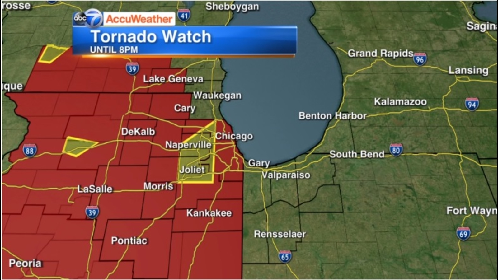
A Tornado Watch was issued for Cook, DuPage, Kankakee, and Will counties until 10:00 p.m. Saturday.
A Severe Thunderstorm Warning has also been issued for Kankakee County until 9:00 p.m.
A Flood Advisory is in effect for Boone and McHenry counties until 9:45 p.m.
A Marine Warning has also been issued for parts of Lake Michigan until 10 p.m.
FULL FORECAST: Watch the latest 7-day outlook
A severe thunderstorm capable of producing a tornado was located near Timerlane, or near Belvidere, moving northeast at 30 mph around 5:50 p.m., according to the National Weather Service. Another severe thunderstorm capable of producing a tornado was also located over Candlewick Lake, or over Poplar Grove, moving northeast at 30 mph at 5:57 p.m.
A tornado-producing storm was also located over Oak Brook, moving northeast at 25 mph around 4:50 p.m., according to the National Weather Service.
STORM DAMAGE REPORTED IN OAK BROOK
As of 5:36 p.m. Saturday, 156 flights have been canceled at O’Hare with an average of 1 hour delay; and no flights have been canceled from Midway airport, according to FlightAware.
According to the Storm Prediction Center, the entire Chicago area is under a “slight” risk for severe weather on Saturday – a level 2 out of 5. There is a 5% probability of a tornado within 25 miles of any given point in the Chicago area on Saturday, ABC7 Meteorologist Cheryl Scott said Friday.
Several rounds of showers and storms are expected to develop Saturday with the potential to turn severe. Threat of storms on Saturday afternoon and evening are contingent on morning destabilization of atmosphere, which scattered storms on Saturday morning may act to inhibit. All storm threats possible, but high winds are most likely, Dutra said.
RELATED: Grayslake teen among 3 University of Oklahoma students killed in crash while storm chasing
Scattered showers and storms are possible earlier Saturday. Rumbles of thunder won’t be surprising, but the better chance for severe weather will be in the later afternoon and evening.
The system heading toward the Chicago area already hit Kansas on Friday and the images coming out of there are terrifying.
Video shows powerful twisters ripping through the town of Andover, a suburb of Wichita. You can see debris flying and power lines sparking as the funnel rips through everything in its path. Much of the city is now without power. So far, there have been no reports of injuries.
Cook County Radar | DuPage County Radar | Will County Radar | Lake County Radar (IL) | Kane County Radar | Northwest Indiana Radar
Copyright © 2022 WLS-TV. All Rights Reserved.