Flood-hit areas of Australia’s east coast are again bracing for more dangerous weather that could disrupt clean-up efforts.
The Bureau of Meteorology issued two severe weather warnings – one for north-east NSW and one for south-east Queensland – on Sunday.
Isolated rainfalls above 200mm are a possibility in some areas, which could lead to flash flooding with the ground already soaked.
The bureau said a slow-moving trough developing over the region on Sunday and Monday would bring heavy rain and ’embedded thunderstorms’ that would shift further south by Tuesday.

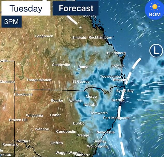
The north-east of NSW and south-east Queensland are expected to be hit with more rain on Monday and Tuesday will could see flash flooding and disrupt clean-up efforts (pictured)

Heavy rain is seen falling before the Super Rugby Pacific match between the Queensland Reds and the NSW Waratahs at Suncorp Stadium in Brisbane on Saturday night (pictured)
‘Locally intense rainfall leading to life-threatening flash flooding is possible with six-hourly totals over 180mm,’ the bureau said.
Tweed Heads, Murwillumbah, Byron Bay, Lismore, Yamba, Grafton, Coffs Harbour and Dorrigo in NSW are included in the warning.
In Queensland the Gold Coast, Brisbane, Sunshine Coast, Ipswich, Coolangatta, Caboolture, Cleveland, Gatton and Jimboomba are affected.
The storm is forecast to set in from Monday morning with coastal areas expected to see the biggest downpours, but rivers farther west are also at risk of flooding.


The Bureau of Meteorology issued two severe weather warnings on Sunday for south-east Queensland and north-east NSW (pictured)

Dozens of rescue boats are going back and forth from homes around Lismore to higher ground as record breaking floodwaters engulfed the town only a few weeks ago (pictured)

ADF and Air Force personnel assist in the cleanup at Lismore (pictured)
‘From Sunday we will see a reinvigoration of the trough that will bring widespread rainfall that will really pick up when it hits the coast on Monday night,’ Meteorologist Dean Narramore said.
‘Over the next few days we will see 25mm-50mm across much of NSW and Queensland.
‘There will likely be renewed river rises particularly through flood impacted areas of south-east Queensland and north-east NSW.’
The Narran River in further west on the border between the states is also expected to get much of the rain with a flood warning in effect.
By Wednesday the weather system should largely move off the coast.
Scott McLennan from NSW SES northern zone said his teams were prepped and ready to respond to calls.
‘We need you to heed the warning, get prepared, don’t drive through floodwater … be wary that landslips are likely, be wary that the culverts may be flooded,’ Mr McLennan told the ABC.
‘If we tell you to evacuate, evacuate. Everything is wet and it is going to be a very wet week ahead.’


A truck driver at Inverell in northern NSW tried to cross floodwaters on Saturday but his 18-wheeler became stuck and SES had to attempt to pull the truck out (pictured)

Already full rivers are at risk of flooding again early this week along the NSW and Queensland border (pictured)
Parts of Sydney were underwater on Friday as severe thunderstorms and heavy rain hit the city with the La Nina system expected to stick around until at least next month.
Taren Point Road in southern Sydney was inundated by flash flooding on Friday afternoon, while trains on the city’s south coast train line were suspended due to heavy rain at Coalcliff.
Rain will keep falling between Sydney and Brisbane over the weekend and right through next week.
Video supplied to Daily Mail Australia showed floodwaters quickly rising up to the level of car bonnets in Sydney.
Several roads across the city, from Alexandria to the Sutherland Shire, also went underwater as motorists insisted in driving through water up to their bonnets – despite repeated warnings against it.
Heavy rainfall also hit Colo Heights north of Richmond and Bilpin in the Blue Mountains as it moved steadily north.

The wet autumn continued in Sydney and the storms slowly pushed north where they were set to deluge towns that have had a disastrous month
In other parts of the country, Melbourne and Adelaide will escape much of the rain and will have mild days with maximum temperatures not exceeding 30C.
Canberra will be slightly cooler and will also see some showers, while a severe storm warning for Perth issued Saturday was called off by Sunday.
Temperatures on the west coast will be warmer with highs around 30C.
Hobart will be cool with a maximum of 21C on Tuesday and will also see some showers.
While the tropical monsoon season in Darwin is still in full swing with temperatures reaching the mid-30s and showers every day for the next week.

Flooding in Sydney on Friday quickly got serious with floodwaters up to the hood of some cars